Making the trains run on time

I visited New York this week, so I get to use its subway, which to me is like the parallel universe London Underground. As I got on the train on Sunday morning, just before cellphone signal vanished, I read Fred's post on the slow process of adding WiFi to the NY Subway. This reminded me of an excellent essay on how the NY subway system is a giant mechanical computer.
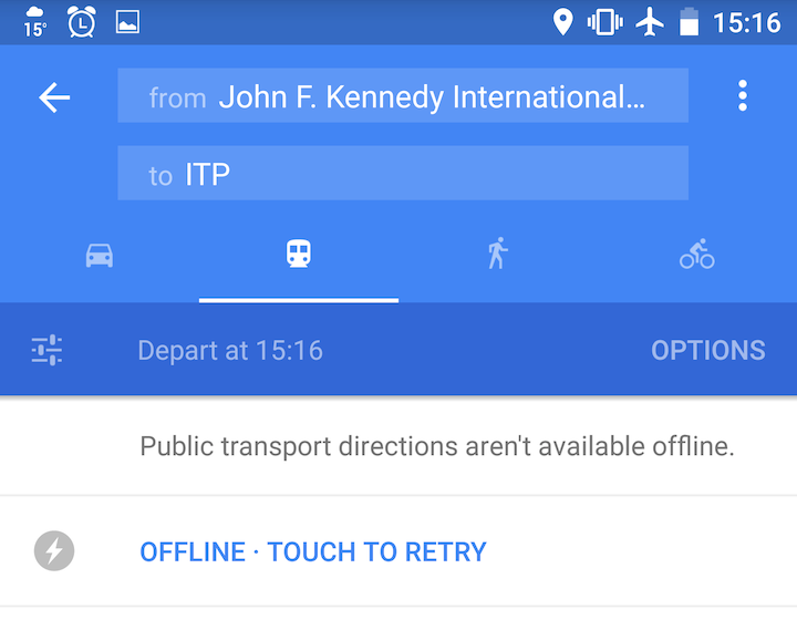
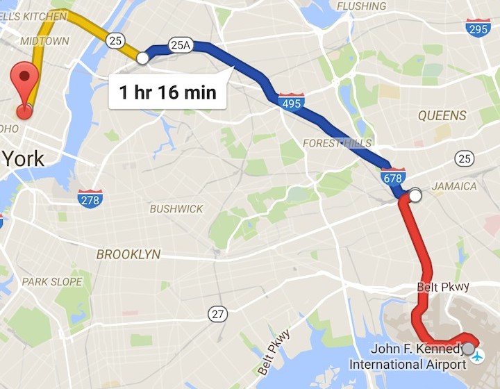
In preparation for this offline experience, I had cached Google Maps of NYC on my phone, but when I tried to compare routes underground, subway routing and even subway lines on the map were unavailable. It would however give me driving directions and times.
This reminded me of another problem with Google Maps Transit directions - it doesn't know when you are on the bus or train already, so it will always tell you to catch the one behind you by walking to a stop if you search to check your connection. This is an odd omission, because it is very good at locating you when driving, cycling or walking (a fun thing to do is to get driving directions, then get on Caltrain and watch Google Maps thrash desperately trying to work out which backstreet by the railway line you are driving on and redirect you back to the freeway). I do wonder if this omission is because Google runs its own buses in the Bay Area, which don't require passengers to make connections, and they have their own app for the timetable.
Now given that Google Maps already uses location data from its users to model and report traffic density, it should be able to work out when you're on a particular bus or train - especially as it can correlate across all the phone-carrying passengers, and see that they are undergoing almost identical accelerations. Which brings me back to the NY subway problem. If Google does this, it will find that it can't track trains underground, because there is no wifi or cellphone data there.
So here's my proposal for Google: sponsor wifi on subway and bus systems, and use it to track the vehicles for the passengers and the transit providers. Just having the drivers carry a cellphone would be one way to do this—Aaron Parecki and the XOXO organisers did that for their conference after all—but correlating across multiple users would be a very robust way of doing this, and give useful ridership data too. The other thing is that enabling all those subway and bus commuters to be connected ot the internet would be very much in line with the general Google policy, embodied in Google Fibre and Google Loon, that the more people use the internet, the more likely they are to use Google services, including Ads and the others that get Google paid. It may seem like a big capital expenditure, but I suspect that compared to the cost of driving every street on earth regularly for Google Maps and Street View, it will be an affordable moonshot.
 Martin Pugh liked this 9 years ago
 Boon Siang Tan liked this 9 years ago
 Aleks S. liked this 9 years ago
 rahul roy liked this 9 years ago
 CathiBea Stevenson liked this 9 years ago
 Saurabh Kumar liked this 9 years ago
 Clint Mendonca liked this 9 years ago
 john jj msinde liked this 9 years ago
 Tony Schutz liked this 9 years ago
 Benedict Evans liked this 9 years ago
 Md. Gulshan Islam liked this 9 years ago
 Karl Puder liked this 9 years ago
 Justin B 🎺 liked this 9 years ago
 Andy Finney reposted this 9 years ago
 Alatitude77-infosec liked this 9 years ago
 lovely mariam liked this 9 years ago
 Rahul Lath liked this 8 years ago
 Brian O'Shaughnessy liked this 8 years ago
 Thorunn Helgason liked this 8 years ago
 Ben Wood liked this 8 years ago
 Rashona reposted this 8 years ago
 CaffieneKitty liked this 8 years ago
 ManoMarks liked this 8 years ago
 Yuriy Dybskiy liked this 8 years ago
 Tom Schenkenberg liked this 7 years ago
 Amanda Goldmann liked this 7 years ago
 priya joseph liked this 4 years ago
 Jolie O'Dell liked this 4 years ago
 Harvey Smith
 Kevin Marks
 Tanya D. ~ Horns Up
 Martin Pugh
 Kevin Marks
 mcc
mcc Liz Fong-Jones
 Bertil Hatt
 ⒹⒺⓃ•Ⓗ ㋡